


Don’t Panic Yet About Thanksgiving Forecasts
November 19, 2021
Many of you have probably heard about the possibly of a wintry storm system to impact the region during Thanksgiving week. While there is a likelihood of there being a large storm system, it is still in that mid-range forecast period.
A tool that meteorologists frequent are computer guidance models also known as numerical weather prediction (NWP). These computer models take information about the current state of the atmosphere and use mathematical equations to show how the weather patterns may change over time.
The two big weather models that are used for mid- to long-range guidance are the European and American Models, and they run every 6 hours. There are others, but those are the two main ones. You may see plenty of long-range model snow maps all across social media. These are usually posted by untrustworthy accounts just looking for clicks and likes. These accounts make it harder for accurate information to get out to the public.
One major thing about these snowfall model maps is that they usually do not take into account other factors. These factors include mixed precipitation such as sleet and freezing rain as well as temperatures. Make sure you do have a trusted source for weather forecasts and information.
The two National Weather Service Forecast offices in our area are NWS Upton which serves Northeast New Jersey. NWS Mount Holly serves the rest of the state.
With all that said, there are different other factors that do go into snow forecasting in general. There is a benchmark called the 40/70 benchmark, which is a big deal in regard to precipitation types along the I-95 from coastal storms. Along that benchmark is the sweet spot for coastal NJ snowstorms. If the storm tracks west of it, warmer air usually floods the coastal plain resulting in mixed precipitation and even a cold rain. The further east the storm track, impacts are lessened for the entire region as a whole.
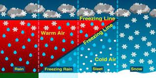
Another major factor in snowfall 9 Different Types of PrecipitationText Box: The different types of precipitation types.
Source credit: https://civilengineersforum.com/9-types-of-precipitation/forecast, is temperatures. When the column of air is above freezing throughout, rain is the dominant precipitation type. The thinner that column of warmer air is, rain becomes less and less of the dominant precipitation type. Freezing rain occurs when there is a thin layer of below-freezing air right at the surface, causing rain drops to instantly freeze on contact with all surfaces.
Ground temperatures also matter with snowfall, as warmer ground temperatures will limit snowfall accumulation. If the snowfall rates are heavy enough that will overcome, and snow can really accumulate well even with temps a bit above freezing.
To wrap things up, snowfall forecasting has many factors that go into it. Along the I-95, more people will notice a slight difference in the storm track as opposed to other less populated areas. Also remember next time you see a snowfall model map on social media before giving a like, click or re-share, consider this information to avoid spreading misinformation!